

Explore Scenic Wonders at Bell Smith Springs
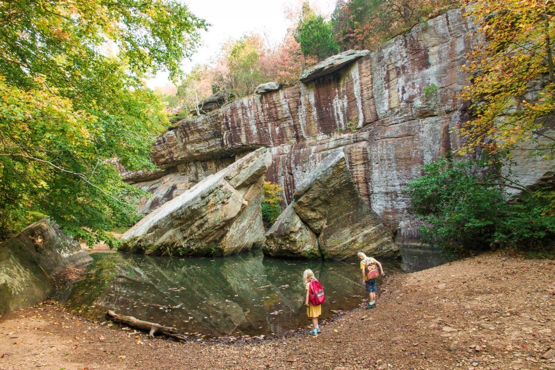
Bell Smith Springs is one of the more beautiful recreation areas the Shawnee National Forest. It contains a series of clear, rocky streams and scenic canyons bordered by high sandstone cliffs and an abundance of vegetation unique to Illinois.
The trail system consists of about seven miles of interconnected trails featuring strange and wonderful rock formations, such as Devil’s Backbone, Boulder Falls and a natural rock bridge.


Directions to Bell Smith Springs
Bell Smith Springs should show up on GPS. The road is gravel, but well graded and well traveled. Depending on which direction you are coming from, here is how to reach the area:
From Harrisburg: Take Highway 145 south 11 miles to Burden Falls Road. Turn right, go 5 miles to Ozark Rd. Turn south (left). Go to Bell Smith Springs Rd. Turn southwest (right) and proceed 2 miles to Bell Smith Springs.
From Vienna: Take Highway 45 north 12 miles to Ozark Road. Turn east (right). Go 10 miles to Bell Smith Springs Rd. Turn southwest (right) and proceed 2 miles to Bell Smith Springs.
On the way, you will pass a turn off to the right that leads to the Hunting Branch picnic area and trailhead. Another turn off to the right leads to Red Bud Campground.
Bell Smith Springs Hiking Trails
There are over three main trails to choose from that interconnect plus a white connector trail. After passing the campground and Bell Smith entrance sign, you will come to a parking area on your left and a vault toilet. You can start your hike from here or continue a short distance to the end of the road for more parking.
From the first parking lot, a trail descends down a set of wooden stairs and to an overlook with a wooden fence.

Sentry Bluff (Blue Trail)
Near the scenic overlook, you can continue down the trail to your right or you can turn left on the blue Sentry Bluff trail which leads to Boulder Falls and makes a moderate, 3 mile loop. This trail is less traveled than some of the other paths and may be trickier to follow. A good GPS and map is recommended.
There are creek crossings along the blue trail where waterproof shoes could be needed. Do not cross if the water is running high after a big rainfall.
Bell Smith Springs White Trail
The more popular route is to continue down the trail to the right from the overlook to reach a set of CCC-era stone steps. These striking steps were carved back in the 1930s or 40s. Take a right to at the bottom to head to the Devil’s Backbone on the white trail. This is the most well known formation here and also a popular swimming hole in the summer.


The white trail continues past the Devil’s Backbone with several route options. Straight will connect either back to the lower parking area or to the Red (Mill Branch) trail. Taking a left will make a small loop to cross the creek and travel to jumping spring. In summer, people climb up the rocks to jump in the deep pool at Jumping Spring. The White trail makes a 1.2 mile loop if you travel the whole path.


Natural Bridge (Yellow Trail)
Another option at the bottom of the stone steps is to turn left. This will lead to the yellow trail and also can connect to the blue trail.
The yellow, or Natural Bridge trail leads to the natural arch. Reaching the natural arch requires a stream crossing which can be high after heavy rain. Generally it is crossable on stepping stones in summer and fall. This moderate trail is listed on the map as just under a mile, while other sources say 1.4 miles for the full loop.

There are several routes to the top of the arch. The first is a metal ladder of steps which is the quickest way on top of the arch but can be slick and not the best idea with young kids. You can also follow the yellow loop trail as it passes by the arch and then climbs over the top. Again, use caution on the top of the arch as it is a long ways down.


Mill Branch (Red Trail)
The final main hiking loop at Bell Smith is the red or Mill Branch Trail. The trailhead for this trail is located on a turn off from Bell Smith Springs. You can also reach the trail by parking at the lower parking area at the end of Bell Smith Springs and taking the trail to the right. The full loop is 2 miles, but it can even be shortened.

If starting from the Mill Branch/Hunting Branch trailhead, the path will first cross the creek. There are stepping stones but it could be tricky if the water is running higher.
After crossing the creek you can turn left or right. We opted to go right and hike counter-clockwise.
The red trail winds up above the creek and parallels the creek. Soon, the creek bed becomes full of large and flat rock. This area is very scenic!
When the trail starts to level out to closer to the level of the rock, you can climb down and explore. Be very careful as the rock can be very slick when wet. If it has rained recently, this area is full of lovely cascades.

After exploring, you can either cross the rock here and continue on the trail to the left on the other side to make a shorter loop. Or you can return to the trail on the side you started and continue to hike parallel to the creek and through the woods. The trail will make a turn left across the creek and make a slight climb uphill through the trees.

The path will pass the same rocky section full of cascades, just now from the other side of the creek bed. Continue along to a rocky creek and another left turn to return to the final creek crossing by the parking area.

❓Things to know:
Distance: The hiking distance can be as long or short as you want at Bell Smith. About a mile round trip just to Devil’s Backbone, several miles if you do full loop trails.
Difficulty: 3-4 out of 5. Devil’s Backbone requires descending stone steps. Other trails may feature steps and rugged terrain. During spring or heavy rain, the creek may be ankle deep or more. You can take a shortcut to the top of the natural bridge by way of a metal ladder which is slick and tricky or take the longer and easier way around.
Scenic Value: 5 out of 5. A must see.
Route finding can be a little tricky. The trails are marked with colored diamonds but intersections are rarely marked and numerous side trails are present. Printing a site map before arriving or taking a photo of the map at the trailhead is recommended. Summer weekends can be popular as this is a favorite swimming spot and the crowds may not be as family-friendly. Arrive early to avoid crowds or hike in cooler weather.
Bell Smith Springs is also used during hunting season, so use caution or avoid during shotgun season.
There are trashcans located near the parking area or campground. Pack out what you bring in. Unfortunately, summertime can bring crowds and litter to the area.
Website: Click Me
You can print a map HERE
Other trails in the area include Jackson Falls , Burden Falls, and Ferne Clyffe