

Take a Paved Path Through Nature at Meramec Conservation Area
Paved trail options at state parks and conservation areas can be limited. If you need an accessible trail, stroller friendly path, or just an easy walk, there aren’t a ton of options. However, Missouri’s Meramec Conservation Area offers just such a trail. A hidden gem near Meramec State Park, this is a fun paved nature trail to visit.

Meramec Conservation Area Overview
Meramec Conservation Area covers over 3,800 acres. It offers a variety of recreation including fishing, hiking, hunting, biking, and horseback riding trails. The site also preserves several historic sites including an old CCC camp, the site of a former log schoolhouse, and an old fire tower foundation.

While the site has several miles of unpaved hiking and multi-use trails, we only explored the paved accessible trail and the short CCC trail on our two recent visits. We will have to try the others another time to see the schoolhouse and fire tower site as well as the additional caves, creeks, and river overlooks.
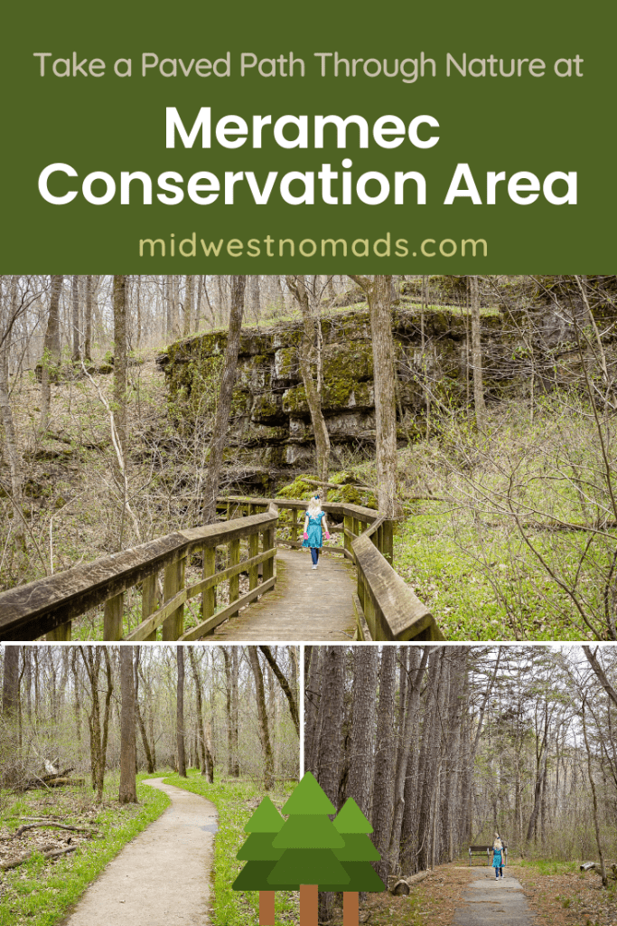
Woodland Trail Hike
- Distance: 1.3 miles round trip
- Difficulty: 1/5. Trail is ADA accessible so it is flat and paved.
- Scenic Value: 4/5. A nice walk in the woods with seasonal wildflowers, a cave, river overlooks, and tall pine trees.
Reaching the Woodland Trailhead
To reach the trailhead for the Woodland Trail from I-44 or Meramec State Park, continue east on Highway 185. Look for the brown conservation area sign on the left next to a communication tower and a brown Department of Conservation building. Drive past the buildings on a well graded gravel road.
A short distance down the road look for a nice overlook and bench on your left. There is a small parking area just a little further on the right if you want to take in the view.

Continue down the road and you will reach a large equestrian parking area. There is a vault toilet here if needed. Keep driving down the gravel road past this parking area to reach the parking lot for the Woodland Trail.
Which Way to Hike?
The trail starts by crossing a bridge over a pretty little creek. In April, this area is carpeted in bluebell flowers.


After crossing the bridge, stay left to remain on the paved path while a unpaved trail goes straight. You will reach a fork to begin the loop. If you want to see the cave first, head right. My kids wanted to see the river first so we went left at the fork.


The path travels through a nice grove of towering pine trees. You could almost believe you are in a rugged state out west.

There are benches scattered all along the trail if anyone in your group needs to take a break.

River Views and Wildflowers
Soon the trail begins to parallel the Meramec River. There are side spurs leading to benches and views of the river. On our last visit, the river was up pretty high. In fact, the campground at nearby Meramec State Park was closed due to flooding. The trail was elevated enough to stay dry on our visit, but I could imagine that it might flood in times of very high water.

Bluebells and other seasonal wildflowers also pop up in the stretch close to the river.


We took a little side path through a large wooded area to view some of the flowers closer.

Viewing the Cave
Near the halfway point of the loop, an unpaved hiking trail continues straight uphill to another overlook while the paved trail turns right to head back towards the parking area. A short distance from this point along the paved trail you will come to the view of Black Onyx Cave.


A boardwalk leads to a viewing platform with an overlook of the cave. If you want a closer look, a side trail travels down along the boardwalk to see the cave and the stream below. Do not enter the cave as it is closed to prevent the spread of white-nose syndrome.


If you visit in winter, you might see some interesting ice formations along the floor of the cave.

Completing the Loop
After the cave, the trail passes over another bridge and an impressive boardwalk. Seasonal wildflowers are located near both of these bridges.


The path continues past another group of pine trees before returning to the start of the loop portion.

CCC Trail Hike
- Distance: 0.25 mile round trip
- Difficulty: 2/5. Fairly flat, might be overgrown in summer
- Scenic Value: 3/5. A historic look at an old CCC camp
Reaching the CCC Trailhead
After visiting the main Meramec Conservation Area, continue back out the way you came on the gravel road past the conservation department buildings. Turn right on to Highway 185. A very short distance down the road keep an eye on your right for an almost hidden parking area in the trees.
History of CCC Company 2728
The Civilian Conservation Corps Company 2728 arrived in the area in the 1930s to build Meramec State Park. They constructed trails, picnic shelters, and many stone structures still in use today.

Around 2,000 CCC workers were enrolled in six-month enrollments at the Company 2728 camp from 1934 to 1942. Their camps had barracks, mess halls and other structures. They were provided medical services, education, and training on various trades. They were paid $30 a month of which $25 was sent home to their families.
Take a Short Walk Past History
The CCC Trail starts by passing underneath a wooden sign with the company’s number. The various stops of the trail are numbered, but there were no brochures listing what the different stops were when we visited. However, there is a kiosk showing a map and photos of the camp. I also did find a list of each stop online at River Hills Traveler.

The trail passes a stone monument and turns right. Soon the trail begins to pass by the ruins of various structures including the wash house, mess hall, and powerhouse.

Two stone chimneys remain from cabins that housed administrative and state supervisory personnel.

The trail ends at the last chimney. Retrace your steps back to the parking area.

Things to Know Before You Go
- Meramec Conservation Area is open daily 4:00 a.m. – 10:00 p.m.
- You can find a park map here.
- Hunting is allowed so use caution when in season. Biking and horseback riding is not allowed during firearms deer hunting season and spring turkey hunting seasons.
- Vault restrooms are located at the large equestrian parking area.
- Pack out what your bring in and Leave No Trace.
More to Explore
Other trails at Meramec Conservation Area include the 5.5 mile Old Reedsville School Hiking Trail and the 10.5 mile multi-use trail for hiking, biking, or horseback riding.
To make a full day of it, don’t miss a visit to Meramec State Park. This park boasts hiking trails, a visitor center, caves, camping, float rentals, plus cabins and a motel. You can even learn more about the CCC in a small museum in the park grill and store.

Have you visited this hidden gem trail?


2 Comments
Kallan
I have never heard of this place!! Thanks for the post! Adding it to my list!
Sara
I could barely find any information on it before we visited! I want to go back and hike the longer Reedsville School Trail.